Madarasi Hargita
Madarasi-Hargita (Romanian: Harghita-Mãdãras) is the highest mountain of the Hargita Mountains and Szeklerland, the northern remnant of the rim of a former stratovolcano crater.
Hargita is the longest and youngest volcanic mountain of the central group of the Eastern Carpathians. According to Géza Czirkusz, its name means charcoal-giving (hair gitan) or stream (aar)-flowing (gintan) mountain in Gothic. The Slovenes explained Hargita to the tuberous, hepehupa mountain, hrgasta (hrga: tuber, tumor). So far, it has not been possible to give a clear interpretation. At the end of the last century (1897), the highest peak of central Harghita was called Galusz-tető. Other names: Nagy-Hargita, Havas, Nagy-havas, Nagyerdő.
The eponymous mountain of Hargita county marks the border between Udvarhely and Csík. It is 70 km long and 20-25 km wide, measured along the Hargita ridgeline. The mountain range separates the Transylvanian Basin from the Csíki Basin. It is bordered by the Somlyó - Délhegy group to the north-west, the Gyergyói and Csíki basins to the north-east, the Barót mountains to the south, and the Rika mountains to the south-west. The mountain range is flanked by the wide volcanic debris plateau of Havasalja on the side of the Transylvanian basin, and borders the foothills of the Csíki basin on the other side.
The Hargita is a series of volcanic edifices formed along the fault line of the Transylvanian Basin. It is characterized by the original volcanic forms: craters, craters, lava flows, volcanic slopes, lava flows, lava domes with steep slopes, tuff benches. Volcanic activity has left behind a stratified igneous crater, where we can find all types of rock, from lava rocks to igneous rocks and volcanic bombs to the ash of glowing eruption clouds. Lava benches are products of lava flow, while volcanic debris refers to explosions. The finer debris accumulated on the lower ridge sections between the volcanic structures, on the ridges, and on both sides of the mountain range. The highest parts of Hargita are occupied by volcanic cones. In some places, we can find the edge of the caldera left at the site of the exploded volcano. The youth of the volcanic structures is proved by the gases of the volcanic after-actions, carbonated mineral waters, wine waters, and thermal waters. Going from north to south, Harghita is divided into Northern, Central and Southern Harghita. The Központi Hargita is the largest volcanic mountain group, extending from the saddle of Nagy-Madaras stream to Tolvajos hágó, where the national road connecting Székelyudvarheli with Csíkszereda crosses the mountain range. This is the largest part of Hargita, with the most complicated rock structure. Hydrogen sulfide and carbon dioxide gas spills, kaolin and ore formations are common. In the area of Hargitafürdő, the older volcanic structure of Nagy – Aratás (1399 m) also comes to the surface.

The center of the mountain block is marked by a huge caldera with a diameter of 5 km, the courtyard of which is drained by the Vargyas stream flowing to the southwest, cutting deeply into the volcanic surface marked by heights of 1450-1500 m. Several eruption centers and swelling cones can be distinguished both on the rim of the caldera and inside it. The peaks of the north-facing, semicircular caldera rim are: Mihály havas (1685 m), Madarasi Hargita (1801 m), Rákosi-Hargita (1758 m), Madéfalvi Hargita (1710 m) and Csicsói Hargita (1761 m). Almost parallel to the Vargyas stream, observing the valley of the Ivó stream, we believe we can also discover the drainage of a volcanic crater.

Some explanations place the Madarasi Hargita tourist settlement on the common edge of two side-by-side volcanic craters. Observed from the summit or the higher points of the "plateau", what was seen seems to justify this explanation.
Madarasi Hargita is the highest (1801 m) part of the Hargita mountain range, it has been sung many times, the "Holy Mountain" of the Szeklers. From the top, you can enjoy a beautiful view of the extensive, 20-25 km wide Hargita plateau, the Libán-tetó, the Görgény mountains, the Gyergyó mountains, and the Hagymás mountains. In the western direction, Ivó-feje, Berszán-sarok, Kecskevész rock can be seen, behind them almost the entire Transylvanian basin. In fine clear weather, the Rika Mountains, Királykő, and Fogarasi mountains can be seen in the south-southwest direction, almost the entire range of the Southern Carpathians. To the southeast we can see the Rákosi-Hargita, to the east the Csíki mountains and the Csíki basin.
Winter sports opportunities
Madarasi Hargita is today one of the most popular ski resorts in Transylvania . The Hargita Mountains are the longest and youngest volcanic mountains of the central group of the Eastern Carpathians, and their highest peak is in the part called Madarasi (1801 meters). The central part of the mountain range, the so-called Central Hargita separates the historical Csíkszék and Udvarhelyszék within the Székelyföld. Its peak is Madarasi Hargita , considered the sacred mountain of the Szeklers.
From the summit, you can enjoy a great view of the surrounding mountain ranges: in good weather, you can see almost the entire Transylvanian basin, as far as the Fogarasi mountains and the Király stone. Among the surrounding landforms, the most important (visible to the naked eye) are the Hargita plateau, the Görgény and Gyergyó mountains, the Libán-tetó and the Hagymás mountains. The Csíki mountains and the Csíki basin are located to the east.

The ski slopes here are at an altitude of 1500 and 1760 m above sea level, the ski season usually runs from mid-December to mid-April, during this period there is definitely snow on the slopes, the quality of which depends on the weather. If the weather is favorable, the ski season can last until the middle of May.

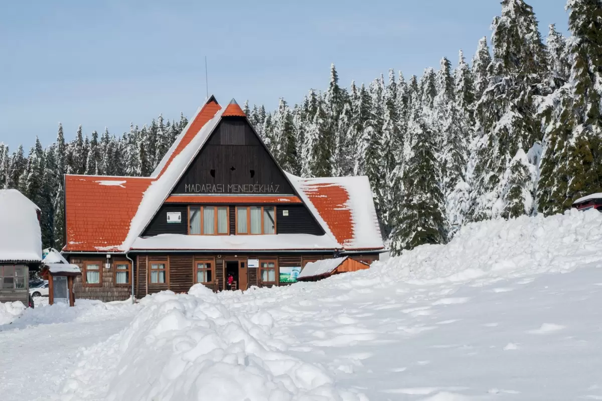
The Madarasi Shelter , built in 1941, is the oldest building on the hilltop, it has been "guarding" Hargita for more than 60 years, and it has been the first building visited by tourists for decades. It is the center of the actual ski resort, which is constantly being renewed, but in recent years a number of small and large guesthouses have made it easier for tourists to find accommodation. The place became so popular, especially after the changes in 1989, that the single shelter was no longer enough to house so many people.